


la bastide d'engras

ajasse
User
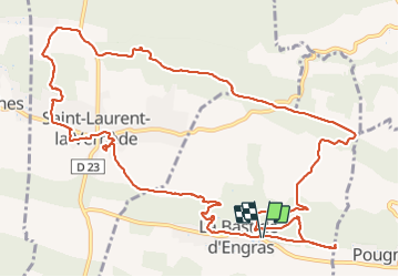

Length
15.8 km

Max alt
279 m

Uphill gradient
274 m
Km-Effort
19.5 km

Min alt
169 m

Downhill gradient
282 m
Boucle
Yes
Creation date :
2021-12-05 08:53:00.381
Updated on :
2021-12-05 14:50:33.315
4h20
Difficulty : Easy

FREE GPS app for hiking
 SityTrail
IGN / Geographical institutes
SityTrail Plus
The world is yours!
About
Trail Walking of 15.8 km to be discovered at Occitania, Gard, La Bastide-d'Engras. This trail is proposed by ajasse.
Positioning
Country:
France
Region :
Occitania
Department/Province :
Gard
Municipality :
La Bastide-d'Engras
Location:
Unknown
Start:(Dec)
Start:(UTM)
618666 ; 4883439 (31T) N.
Comments